Alpena saw less snow in December, blizzard that never came
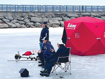
News Photo by Steve Schulwitz Ice fisherman patiently watch their tip-ups while fishing at the small boat harbor in Alpena on Monday. Temperatures were near 40 degrees yesterday, which was above average for early January. December was warm and had well below average snow totals.
ALPENA — When Alpena residents look back on the weather in December of 2022, they may think about the blizzard warning and forecasts for high snowfall totals that never really materialized.
A winter storm, which did impact millions of people in Michigan, led to power outages and treacherous travel around much of the state. But in Northeast Michigan, it fell short of expected totals, which were initially forecast as one to two feet over a 48-hour period with possible higher amounts due to drifting snow.
The 2.3 inches Alpena did receive during Winter Storm Elliott quickly melted after a warm spell arrived.
Alpena received about half of the snowfall it typically gets for the month of December. It received only 9.6 inches — well below the long-term average of 16.9 inches.
The snow the area did receive never stayed long because of mild temperatures that rolled into the area shortly after the ground turned white.
For the month, the average high temperature was 34.6 degrees, which eclipsed the monthly average of 33.6 degrees. The warmest day was on Dec. 30 when it warmed to 56 degrees, which broke the 51 degree record established in 1936.
Alpena wasn’t without its cold days as low wind chills and temperatures in the teens overtook the area over the Christmas holiday. Still, the average low temperature for the month was well above the historical average. The low temperature average for December was 24.7 degrees, which was above the 19.6 degree long-term average.
The average temperature last month was 29.7 degrees, which bested the monthly average for December by 3.1 degrees.
A brunt of the snow Alpena received last month came primarily during two weather events. A total of 2.2 inches fell on Dec. 6 and nearly three inches from December 22 through Christmas Eve.
The National Weather Service predicted the holiday weekend storm would bring more than a foot of snow but, in Alpena, it never came to be.
National Weather Service Meteorologist Sabrina Jauernic, who works at the Gaylord office, said there were some areas in Alpena County further from Lake Huron that got as much as four or five inches of snow.
She said in Alpena and Alpena Township, the early hours of the storm set the stage for its lack of intensity later.
“It rained more and for longer than what the models predicted,” she said. “That really impacted the snow totals.”
For the first half of January, Jauernic said the weather will be a bit milder than normal. Outside of a change or rain and light snow flurries later in the week, there doesn’t appear to be any winter storm on the horizon.
“It looks like it is going to be warmer than average and it doesn’t look like there will be a lot of snow, at least for the next week,” she said. “It really looks like it is going to be quiet for the first part of this month.”
Local News
Learning to fly

Defense motion to suppress evidence denied in Wardlaw case
Art on the Bay
ALPENA - It is that time again. The Thunder Bay Arts Council's 49th Annual Art on the Bay is scheduled for July 18, ...

Running a mile
Construction begins on education project at Alpena’s Duck Park