Flying over Canadian wilderness
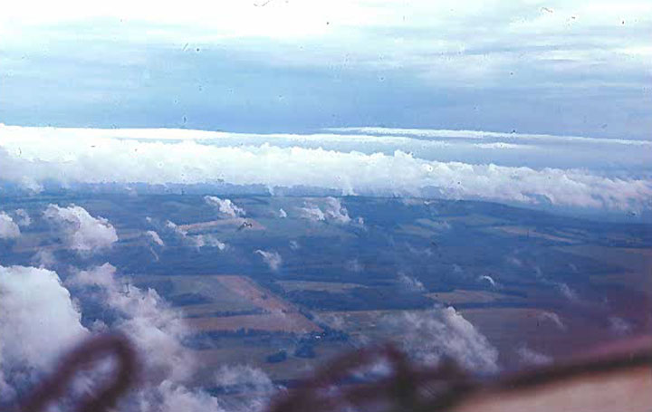
Courtesy Photo The Grand Prairie area in Alberta, Canada, with billowing clouds, is seen through the window of William Kelley’s plane in July 1971.
EDITOR’S NOTE: The following is the 16th in a series of stories adapted from William Kelley’s book, “Wind Socks, Grass Strips, and Tail-Draggers.” Last week, Kelley made a muddy landing in Edmonton and pitched his tent beside his plane.
It still rained when morning arrived.
Before there was much light, I dressed and packed the tent and gear in the plane. I hated to pack a wet tent, but there was no other choice.
When I walked into the terminal to eat breakfast, nothing was said. Either they didn’t notice or didn’t care as long as there wasn’t a “tent city” at the airport.
A high overcast layer of clouds covered Edmonton when I left that morning. The layer extended to the northwest for several hundred miles, according to Flight Service. The visibility was quite good, however, and the air was smooth.
There had been a little rain or mist as the plane was fueled, but I was careful to not let water enter with the fuel.
I tried to keep the mosquitoes at bay, too, but some still managed to bore right into me, their little proboscises sticking in front of their labial palps like fuel hoses on a mid-air tanker.
One of the warnings folks gave me about going to Alaska was the insects — mosquitoes and black flies. The mosquitoes were as bad at Edmonton as I had been warned. I hoped they weren’t as bad in Alaska, as I’d been told, and I surely didn’t want to encounter those black flies. Thank goodness there were none on that trip.
Even though Edmonton isn’t in the mountains, some of the weather in the area is directly influenced by the mountains farther north and west.
The road I planned to follow curved northward and gradually lifted. The elevation increased and the flatness of the terrain became rolling.
Ninety miles northwest of Edmonton, a little town called White Court is situated on the Athabasca River. In that region, there are some serious hills, but no mountains.
On that morning, the low ceiling produced by an occluded front caused clouds to form on the river like a fluffy blanket. I circled a lumber yard as I debated whether or not to go any farther.
Along the river and northward of White Court, the terrain rose still higher, and the clouds seemed to merge with the ground. Also, occasional clouds along the river seemed to blend with the low overcast. I wasn’t sure I wanted to stick my nose into a situation where it might be bloodied.
Finally, I decided to try it, with the full intention that I would do a 180-degree turn if I couldn’t handle what I saw. The condition at White Court was local. The sky improved to the northwest. I continued toward Grand Prairie.
After I left Edmonton, the rain quit. A little later, it began again. Clouds raised and lowered. Some places were quite windy, others calm. At that place on the Athabasca River and northward, there must have been two or three weather fronts competing for the spotlight.
The air became colder. I had to turn on the cabin heat, and it was July.
I wound my way along the rivers and roads that intermingled with hills. A little farther, the ceiling lifted. I relaxed a bit, but still followed the road.
Several miles southeast of Grand Prairie, the road curved north. I was headed to the northwest. To save time and miles, I chose to fly the last 50 miles on a straight line to Grand Prairie.
I was kind of low — not below 500 feet, though. The air was smoother at that altitude. The weather and terrain were responsible for some serious updrafts and downdrafts. I took that as a sign the ceiling was rising.
On I flew.
There was nothing beneath me but trees and streams. There were no roads or lanes. At the low altitude, I couldn’t distinguish any landmarks for reference. Visibility seemed to diminish as soon as I left the road. It might have been anxiety that made it seem so.
I was low enough that I couldn’t find any land features as reference for navigation. I looked out each side window and ahead. All I could see were trees and clouds. At one point, I slowed down because the air was so rough and I didn’t want to put extra stress on the 140.
I kept my compass heading and hoped. About 30 minutes after I left the road, I saw a stream. Just past that, fields began to dot the countryside. I entered more of the prairie, leaving the woods.
A few miles back, I had spotted a lumber road. I noted its location and thought I’d land on it if conditions worsened.
Now, there were fields.
Finally, in the distance, I saw some smoke. Usually, smoke is not a good thing. It means pollution. But I knew Grand Prairie must be near.
A moment later, a highway appeared on my right side. I was on course.
A month earlier, the airport at Grand Prairie had commissioned a control tower, but the frequency wasn’t on my charts. A few miles from town, I contacted Flight Service. They told me to switch to the tower and gave me the frequency. By that time, I was five miles from the airport.
I contacted the tower and gave my position. The controller advised me to report 10 miles out on my return trip.
The tower gave me the winds and cleared me to land on the west runway.
Check The News next week for the next installment. William Kelley was a teacher for 32 years and has been a pilot since 1966. He lives in Herron on the family farm where he was born and raised.
Local News
Longing for summer

Alpena MSP post accepting donations for survivors of sexual assault

Harrisville library hosts Sole Survivor program
Gubernatorial candidate Mike Duggan visits Rogers City
Trail Roamers donate to Friends Together