
Take a virtual field trip to Marine Sanctuary Tuesday
Trending
ALPENA — The National Oceanic and Atmospheric Administration on Tuesday will host a virtual field trip to learn about how scientists explore the bottom of Lake Huron and discover what lies below the surface.
Research Coordinator Stephanie Gandulla will lead the virtual field trip through the Thunder Bay National Marine Sanctuary, which begins at 11 a.m and is hosted through the online platform Exploring by the Seat of Your Pants. While the trip is free, registration is required through thunderbay.noaa.gov.
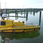
Gandulla will speak about research that occured last summer when NOAA partnered with the Ocean Exploration Trust and the Great Lakes Environmental Research laboratory to map the lakebed using autonomous surface vessel BEN — or Bathymetric Explorer and Navigator.
Gandulla will also talk about another lakebed mapping project with the researchers that will take place next summer. The research was originally scheduled to kick off on Monday, but was pushed back a year because of coronavirus.
"Normally, this time of year, we would be engaged in a lot of public programs, we'd be out on the lake doing research, and, since we're not able to do that, we are working hard to offer virtual experiences and virtual ways for people to get into their sanctuary," Gandulla said.
While the marine sanctuary spans 4,300 square miles of Lake Huron off the Northeast Michigan shoreline, less than 20% has been mapped.
Scientists last summer mapped a swath of lake bottom just off the shores of Rogers City using technology that emits sound waves. While they discovered many interesting geological features, no shipwrecks were discovered.
While scientists are always looking for shipwrecks, Gandulla said, there are many other uses for the data they receive from scanning the lakebed. For example, she said biologists may be interested in what certain fish habitats look like and geologists may be interested in geological features such as sinkholes.
Because the research was pushed back a year, she said scientists will have more time to dig into historical records and determine which part of the sanctuary they want to explore.
"There's at least 100 more shipwrecks in and around these sanctuary waters left to be discovered," she said. "We have historical records of more ships that have not been found, which makes our job very exciting."