Alpena accumulates 0.43 inches of ice, more winter weather on the way
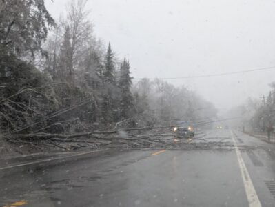
News Photo by Reagan Voetberg A tree lays across U.S. 23 South during a minor ice storm in the Alpena area late Tuesday and part of the day on Wednesday. The fallen tree forced motorists to navigate their vehicles around it until it could be removed from the right-of-way.
ALPENA – Northern Michigan woke up to a layer of ice on pretty much everything outside on Wednesday morning. Adding additional time to your morning commute just to chisel ice off your vehicle.
National Weather Service Meteorologist Eleanor Delizio said the weather system and the total ice accumulation as of Wednesday afternoon exceeded what was forecasted.
“When we issued the ice storm warning we were anticipating a quarter inch of ice accumulation for the Alpena area,” Delizio said. “At the airport in Alpena, so far we have 0.43 of an inch of ice, that is one of the higher reports we have received.”
The Weather Service was initially expecting more sleet for Alpena and our section of Northeast Michigan.
“We did get that mixed precipitation but the predominant type, especially for Alpena, was freezing rain,” Delizio said. “We did communicate the potential of getting those higher amounts of ice accumulation, but where we were expecting more sleet, it ended up being ice.”
We got our fair share of ice accumulation, however, most of the severe storm activity missed Alpena.
“Although we did get some thunderstorms, and periods of heavy rain, the heavier storm activity stayed to the south of us,” Delizio said.
A weather system is expected to move into the Alpena area on Friday that could bring up to three to five inches of snow, the forecast for Sunday is not pretty as the National Weather Service has a 95% change of five to eight inches of snow during the day and an additional five to eight inches during the night time hours and early morning hours of Monday.
Delizio said that forecast could change, as predicting the weekend storm has been challenging.
“There is a lot of uncertainty for what Sunday will bring, we know that there is going to be a stronger system that tracks somewhere over Michigan,” Delizio said. “However, nailing down that exact track is difficult, depending on where it tracks, it means different things for Alpena.”
He said there is a high probability the Alpena area will receive some type of snow, ice, or sleet.
“There is a chance for high, wet snow accumulations, but there is also a chance it might be more of a rainy/wintry mix,” Delizio added. “There is also a chance for a high impact event with some sort of wintry weather, for Sunday.”
Currently, Alpena is stuck in an active weather pattern, which means periods of snow/rain, followed by a brief break, and then more wintry weather activity, Delizio said.
“Because we have an active weather pattern right now, we are going to see these brief breaks, and then the next system moves in,” he said. “For instance, snow is expected for Friday, and then we will see a break on Saturday as that system exits, and the next one moves in.”
The current weather model for Alpena is leaning towards wetter, and cooler than normal for the next 10 days.
“We are leaning towards below normal temperatures for the next six to ten days, as far as long term, it’s hard to predict,” Delizio said. “As we get towards the end of the month we could see periods of warmth, but the trace of temperatures is a little up and down, and the weather pattern is expected to remain active.”
Local News
Alpena County grants committee meets today
ALPENA — The Alpena County Grants and Contracts Committee meets today at noon in the Howard Male Conference Room ...
Alpena accumulates 0.43 inches of ice, more winter weather on the way

Rep. Cavitt, House Republicans secure federal funds for ice storm recovery
Busy month at Presque Isle District Library

Alpena County commissioners approve ballot language millages
